
G1. Shopping Centre

General Overview
Summertown is a wide avenued, well-landscaped and successful district shopping centre. The aim of the Neighbourhood Plan is to keep it that way, protecting and enhancing its physical character, including key building forms, special buildings and terraces, its greenery and street-scene features.
Both Banbury Road and South Parade are very busy streets, but the setting back of buildings from the road, the trees and the relaxed streetscene work well. The mix of uses has moderated the impact of the traffic and enabled the centre to be comfortable, and user-friendly – a destination at which to spend time, not just a shopping centre.
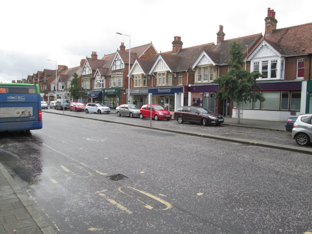
The appearance of the centre whether approached from the city centre or from the north down the Banbury Road is positive and welcoming because of its wide pavements and trees. It is unusual for a city high street because it is compact, less than half a mile in length from Marston Ferry Road to Portland Road. Both ends of the shopping centre are enclosed by residential development. South Parade is a specialised extension of the shopping centre, linking the Banbury and Woodstock Roads.
Summertown centre is also unusual because the retail units are set back from the main road itself creating wide spaces for walking, bus stops, cycle racks and pavement cafe areas. This is a huge asset.
Building forms, scale and architecture contribute strongly to the character of the centre. The Victorian terraces on the West side of Banbury Road and in South Parade form an important part of the character.
The larger modern office/retail blocks on the East side of the Banbury road are of a reasonable scale and fortunately are set back from the broad pavement. It would not be acceptable for this type of large plot development to encroach on the West side of the Banbury Road – except perhaps in the case of Suffolk House, a low-level block which currently houses Tesco and Sainsburys mini-supermarkets. This building is not an attractive feature of the centre. Apart from Suffolk House, the West side consists of a distinctive Victorian terrace, made up of pairs of shops with residential flats above, under steeply-pitched tiled roofs.
South Parade is another early Victorian street, dating back to the earliest days of Summertown but much altered. Here restaurants dominate the street scene but there are also two hairdressers, an art gallery, a kitchen design shop, a wholefood shop and dress shops. West of Middle Way, the street becomes more institutional with Summertown Library and two schools: St Edward’s and Northern House.
History
Banbury Road was the main access route from the North to the historic City of Oxford. There was a turnpike further north towards Wolvercote and, in the early years, the spires of Oxford would have been visible from the high road.
Diamond Hall, a public house notorious for highwaymen, was the only building in this area in the 17th century. Further building started in 1820 and in1889 Summertown was incorporated into the City of Oxford. The public house is gone but the ancient row of Diamond Cottages still remains behind the first shops of the Summertown Centre. Major development came quickly in the 1890s, by which time the West side of the Banbury road shopping area had been built.
The East side is clearly much more recent and was built at a time when pastiche-Victorian style was not in fashion.
The further development of Diamond Place should respect its heritage of place and name.
Issues
– Concern about the loss of character when traditional shops become unsustainable because of high rents
– Heavy traffic, especially at peak hours
– Traffic ‘rat-runs’ through South Parade to the Woodstock Road
– Lack of cycle parking frames
– Change from single lease units to combined unit occupation
Assets
Landscape
– Greenery on wide pavements outside Prama House, M&S and Co-op on Banbury Road,
Unitarian Church and St Anne’s College premises on South Parade
– The old stone wall alongside St Edward’s School on the South side of South
Parade
– The old stone wall beside Prama House
– Well-designed public pavement spaces
Transport
– Excellent bus services
– Balanced parking facilities
Buildings
– A mix of retail/residential and community uses
– Many small single unit shops
Significant buildings
– Unitarian Church
– Twining’s House
– Dew Drop Inn
Public services
– the Library
– two NHS surgeries and three dental practices
– public toilets
Guidance for new development
To ensure
– that the setting back and existing well-established plot sizes do not change,
especially for the important Victorian terraces on Banbury Road and South
Parade
To retain
– the mix of retail/community services and residential
– single leases on buildings to prevent larger stores coming in
To mitigate
– rat-running down South Parade, through traffic management measures
To reduce
– traffic on Banbury Road especially during peak periods
To protect
– the existing trees and enhance the green streetscene
– significant buildings of local historical and architectural merit
– community amenities – particularly the library and the NOA Community Centre